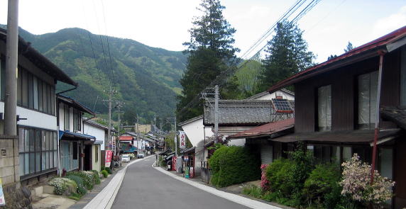
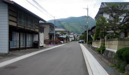
本文へスキップ
Wada, Nagawamachi Town, Nagano Pref.
 
 
Stage-Town in Greenfields

  On Nakasendo in Shinano the place nearer Kyoto has been assigned or called Kami(上), i.e. upper in usual. But in some stage-town the place heigher have been called Kami, for example in Shiojiri.
  In Wada the area nearer Kyoto has been assigned the upper town owing to the usual method. But pronunciation of 上町 is Kanmachi by euphonic change.


▲View of Nakamachi from Kanmachi

  For the number of travellers and goods staying at Wada town in front of Wadatoge pass had been increasing rapidly until early 17th century, the scale of the stage-town was to be enlarged in additon to two older towns.
  Thereafter the new town was to be called Kanmachi, one of the older Nakamachi and another Shimomachi. Nakamachi means the middle town and Shimomachi does the lower town.
  But they couldn't meet the increase. Then on the north side of them, in Hashiba and Shinden, two newer towns were built. Hashiba means the place of a bridge and Shinden does the new field. Urban areas reached about to Hachiman shirine.
  The length of the stage-town street grew to 900 meters and the household increased to 110. The town had one Honjin, as a main official inn, and two Wakihonjins, as its deputies. The latter took the role of Toiya to relay transporting tourists and goods along Nakasendo.


▲Distant view of Asama mountains from paddy fields
of Kanmachi

  Hoevwer the town-houses were standing only in one line on each side of the road. The farm fields were spreading behind them. It was a middle size of the stage-town surrounded with fertile agricultural fields and mountains.
  And until now such a landsape has been kept. It is common feature of Nakasendo in Shinano.

■Around Kanmachi

◆Views along Kaido

  Though the allocaion of house-sites in Kanmachi along theroad has remained the traditional form, the shapes of houses itself have already changed into the contemporary style.
  Howver some of old town-houses of Dashibari architecture has been conserved. Almost of them are out of life. Therefore the town can hold and keep them.
  Gettiing nearer to the core of the town, we would find the traditional townscape.


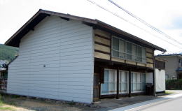
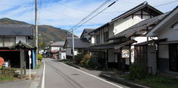
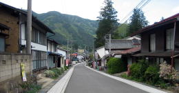
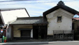
▲A house of Dashibari architecture

  The picture above shows a house having kept the traditional style but I suppose it was rebuilt in Showa period. Because it has a short depth. As the house-site shape there has had a narrow front and long depth, if it was old one it has such a shape.
  In the traditional case the a back side roof was to continue longer to reach to the eaves of the first storey. And there were a warehouse,a vegetable field or a inner garden behind the mainhouse.


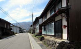
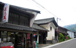
▲The ain shop-house with Udatsu and a mud-walled warehouse▼

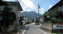
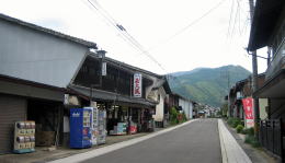
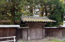
◆What was the gate ?◆

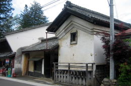
  By the way there is a site of ruining houses, already out of life for long time, next to Yorozuya shop. And on its front-side facing the road an old Yakuimon gate is atanding.
  What was here ? I heard that the chief of the village lived here. It is a trace of those days, isn't it ?


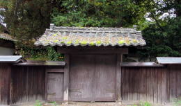
▲The state 6 years ago.

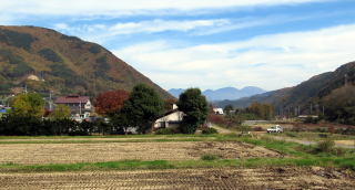
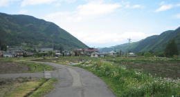
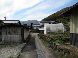
◆Circumscibed with Fields◆

  The farm fields are circumscribing Wada town along the road. Furthermore the mountain-sides are creeping immediately behind it on the west side. It is a town on the ravine surrounded by the mountains heigher than altitude 1000 meters. That is a geographic condition common to many stage-towns along Nakasendo.


View toward Nakamachi from Kanmachi

Around the site of Kosatsuba

View toward Kajiashi from Ksatsuba

A peak over there is Ooideyama

Yorozuya's Udatsu wall has got into view

A bit of traces of the old days

Looking back near Yorozuya shop

Warehouses of mud-walls covered with white plaster

An old Yakuimon gate next to the shop has gotten devastated these years. Recently it was restored on the base of the plan restoring the townscape. They are proceeding tha plan now.

Restored Yakuimon gate

Farm fields are spreading over immediately behind the house-lines of the town
Going on a path crossing Kaido at Kosatsuba, we get into a farm area.
 
Information

Walking Map around Wada

  • Geography around WadaTown
  • Central Area of Wada

Historic Map of Wada

  • Change since Age of Medieaval Castle-town
  • Tracing the town's developmant

Map for Wadatoge Trekking

  • Map for Pass-Walking
  • Information about Historic Sites

Walking around Wada

  • Around Wadajuku Station
  • Neighborhood

Situation near Oikawa in Edo period

  • Vertical Section of Kaido
  • It was so difficult to travel

History of Nakasendo

  • Institution of Kaido and Stge-Towns
  • Shogunate Regime and Kaido System

Architecture of Town -Houses

  • Town-Houses along Nakasendo
  • Learn to enjoy town- walking

中山道の絵地図

  • 京と江戸を結ぶ中山道の絵地図です。
  • 東海道や日光街道、甲州街道、北国街道との連絡を図解。

信州の街道連絡絵図

  • 信州には多くの街道が通っていた。
  • 新旧の中仙道の経路を比較できます。

中山道宿駅一覧絵地図

  • 中山道のすべての宿駅を図示。
  • 中山道の旅を楽しもう。

中山道の町家造りの説明

  • 奈良井宿の町家造りの仕組みの解説です。
  • 街並み探索がもっと楽しくなります。

木曾路の絵地図

  • 木曾路のすべての宿駅を表示した絵地図です。
  • 木曾路一帯の名所や観光施設の案内に役立ちます。
のんびり写真館

街歩き写真館

木曾路・奈良井の心に残る風景写真を特集

  • 街並み景観、風物
          フォトギャラリー
  • 木曾路・奈良井散策

奈良井まちあるき

小布施まちあるき

別所温泉まちあるき

塩田平をめぐる旅

◆ブログ風の記事案内を見る

|  previous page  |  next page  |