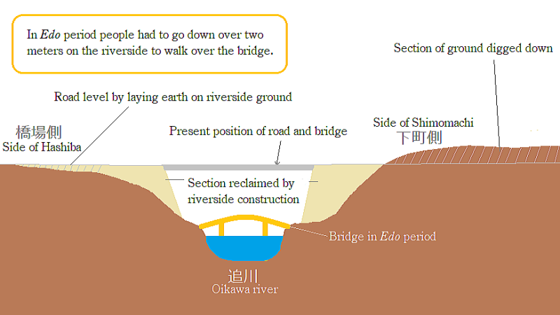
Old Nakasendo near Oikawabashi Bridge ― A Vertical Section
The picture above is showing a vertical section about Oikawabashi bridge of Nakasendo in Wada town. It exaggerates the vertical size.
In Edo period the road structure was following the natural landform owing to the technology of engineering of those days. The ground lavel on Shimomachi side was higher by 1.5 meter than nowadays.
![]()
▲Stone-wall and stairway of Kokuya facing Kaido
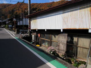
▲Ground level of house-site is lower than road
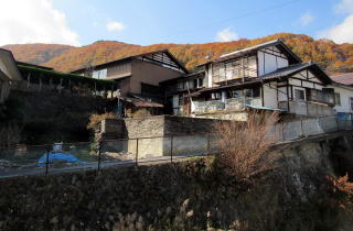
▲Height gap of bank viewed from another reverside
The houses of Yamakiya, Daikokuya and Kouchiya are now standing on the stone-walled terrace. But in the old days their ground level was on the same level as the road. After Meiji period the road-ground has been gradually digged down. Then the height gaps were covered with stone-walls and they come up to their houses through the stairways.
I suppose that the reconstruction by digging down reached near Honjin, because its site is notn covered with the stone-wall. Some old persons told me that the road was waving up and down like a camel's back about 70 years ago.
In contrast, the ground of Hashiba area, on another riverside, was lower. Then they lie earth on the road to raise it by about 60 centimeters. Therefore the ground level of house-sites became lower then road.
On the other hand, in the old days the wooden bridge over Oikawagawa was set on the position lower by two meters than nowadays. Then the bridge had been broken by flood and rebuilt often, I suppose.
Moreover, the height gap between the road level on Shimonachi side and the bridge had to be over four meters.
In those days even on the stage-town street of Nakasendo the road got down on the river-ravines deeply, it was very danger for the carts to go across the river. It was very difficult to go down safely and to go up.
Please suppose that three people could anyhow manage to carry a cart loading rice or stones on the street-slope.
See the third picture above shows a view of houses in Shimomachi from another riverside. They are standing on the rather high bank covered with stone-wall. To go across the river, they had to walk down to the lowest point and climeb the steep slope.
Hoever since Meiji period until now they have digged down the ground on Shimomachi side and laied earth on Hashiba side to dessolve the heigt gap between them. Thus they has changed the landform suitble to car traffic.
The travellers walking Nakasendo went down and up large gaps often even on the town-street in Edoriod. It is not so easy for us who get used to the contemporary traffic conditions to understand the their minds and efforts.