Changing from Castle Town to Stage-Town
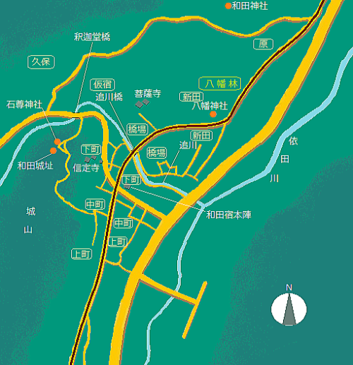
Names of the places on the map :
Temples and Shrines 信定寺: Shinteiji 菩薩寺: Bosatsuji 和田神社: Wadajinja 八幡神社: Hachimanjinja 石尊神社: Sekisonjinja
Villages 原: Hara 八幡林: Ywatabayashi 新田: Shinden 仮宿: Kariyado 久保: Kubo 橋場: Hashiba
下町: Shimoachi 中町: Nakamachi 上町: Kanmachi
Mountain: 城山: Shiroyama Others 追川: Oikawa river 依田川: Yodagawa river
釈迦堂橋: Shakadobashi bridge 追川橋: Oikawabashi bridge 和田城址: Site of Wada Castle 和田宿本陣: Honjin of Wada Town
■Lord of Wada-Manor and Castle■
The picture-map above is a material for studying the changing process of Wada villages from the period when the Wada-Oois dominated them as a landlord to Edo period. But the map shows the roads and the villages what and where they are now. I suppose that in 15th - 17the century they were different very much from those in nowadays.
It is seaid that the Wada-Oois were a branch family of the Oois dominating the areas of Takeshi and Yoda. The latter was also a clan-branch of the Oois ruling over Saku province. Then we would suppose that there ware a hierarcy of landlords in which the manor of Wada was a fief attributing to Takeshi-Yoda domain which subjected to the Oois in Saku until the last phase of the war age.
Therefore when the Takedas in Kai invaded into Shinano country to administrate it they had to gain mastery over not only Saku but also Takeshi-Yoda and Wada.
By the way the Wada-Oois held a castle-fortress at the northeast side of the ridge called Shiroyama, which was called Uenoyama or Komineyama. The manor house of them was standing on the north side of Shinteiji temple, I suppose. Their vassals held their houses on the place from Shinteiji temple to Shakadobashi bridge.
Then Oikawa river functioned for a natural moat guarding on the west, the north and the east side. The core of the castle-town was on the south side of Shakadobashi. The towns scattered from Kariyado to Shinteiji temple or Shimomachi.
Farmers villages surrounded the castle-town from the south of Shimomachi to Nakamachi on the foot of Shiroyama, northward on Kubo and Kariyado and eastward along Oikawa on Hashiba. We don't know the names of the towns of Shimomachi and Nakamachi in those days.
Because the area from Bosatsuji to Hachimanjinja is on the northeast ― the unlucy direction ― of Wada Castle site, some temple or shrine was allocated for a kind of insurance. Therefore some farm fields or settlements had to be formed from Shinden to Yawatabayashi.
As Wada manor was a furtile granary with rich water resource, people was treated cordially under the rule of the Takedas. The administrating organization of the villages and its rights were still kept. The leading families were admitted to build Shinteiji in order to pray for Ooi Nobusada who had been thier lord and killed by war with the Takedas.
I guess that most of them accepted the proposition ob the Takedas before the battle. The best way to dominate new domains in the war age was to gain control without battle. Therefore the warlord restricted the aim of warfare to destroying the counterpart refusing a surrender by win with negotiation.
Such a art of war may be reflected on the rule of Shogi, i.e. Japanese chess, in which aeach game master can use the pieces(warriors) captured.
■Establishment of Nakasendo and Growth of Stage-Town■
Long later at the beginning of 17th century the Tokugawas' Shogunate government astablished Nakasendo as one of the main official roads connecting Edo and Kyoto after getting the hegemony. Then they planned to construct the stage-town Wada in front of the steepest point, Wadatoge pass.
The clan of Matsumoto was ordered to build the stage-town. They built some villages, which would be Nakamachi and Shimomachi some decades later, on the south side of Oikawa river for a temporary solution. And they made people living near areas to immigrate into ner towns under some good conditions.
However so many travellers and goods got used to stay at the town lying just before the steepest pass-way that a the size of the town had to be enlarged within a half century. The transporting and tourist market was growing rapidly.
For a time a new town which would be called Kanmachi later was formed by immigration from Kubo village and Kajiashi. But the number of tourists and traffic were increasing furthermore quickly. Then in 18th century the town-area was enlarged again northeastward to Hachimanjinja. Its street length reached 900 meters.
As the stage-town was growing at haphazard in such a way, they could not build formal Masugatas at both entrance to the town. But they made the road turn in front of Hachimanjinja to form a military defence at the nort end of the town. And about the south side they treat the steepest mountain-path of Wadatoge as a defence structure.
The town-area of from Shimomachi to Nakamachi had been built for a temporary solution at the beginning and Kanmachi was built later owing to the traffic growth. We would read out that from the site-allocation of them. See a picture-map beneath.
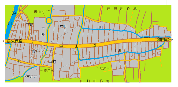
■Site-Allocation of Town■
The picture-map above is my supposition which is base on my fieldwork about the town and the picture in a article in 『和田村誌』, Encyclopedia of Wada Village, by its education commitee. It shows the site-allocation just after construction of Kanmachi.
It shows the fact following. In the area of Shimomachi and Nakamachi some farm village or towns under the castle had been formed before Nakasendo was established. Then the allocation of the house-sites had been made spontaneously and its shape had benn irregular. But the stage-town had to built on the base of the site-allocation aready fixed and the holding rights of habitants on the sites.
In contrast to that the site-allocation of the new area of Kanmachi is regular and the town was to be build largely on the base of some prearranged plan about allocation of house-sites in away. But they were not perfectly rectagular because some houses of farmers had been already standing there.
■Utility Formes of Sites■
I spite that the shapes of sites were regular or spontaneous, generally speaking each of them had a narrow front and a long depth. How they were usued ?
 In the cases of the merchant, he arranged a shop-house as main one on front side along the road, a warehouse or residental house behind them. In the case of the inn, the master arranged a inner garden behind the main house for staying. But they kept some space behond them in their sites.
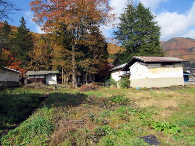
I guess from the experience in the castle-town MatsushiroM that they cultivated farm fields for vegetables or paddy. There were farm fields behind the houses in Matsushiro, in the case of low class vassals. Not to mention Wada was in the granary area.
The picture obove shows the back yard of Hontei Nagai site. A large space was kept for a farm field, I suppose.
In drawing the picture-map above, I suppose in or along the sites the water-way was running through. It was utilized for irrigation of fields.