|
In the central area of Matsumoto City a beautifl castle with calm presence has been conserved. It has the core. I find the cityhood about it. The castle looks not gorgeous but rather simple and strong.
Each street and town in the city has their individuality and own unique shape, about which I feel vividness. They get together to make the character of the city as awhole.
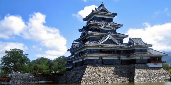 ▲Main tower standing up into sky ▲Main tower standing up into sky
The city is on the east part of Matsumoto Basin. The basin, which once was a huge lake, has been formed by the rivers, branches of Sai-gawa river. They flow down, with erosion and accumulation effects, from the mountains and highlands surrounding the basin.
⇒Map useful for town walking
■History and Geography of Castle■ |
|
Matsumoto Castle had been called Fukashi Castle in the older days. It was said that the castle was built by the Ogasaswaras who were the lord protector of Shinano country.
From the last phase of Nara period to the eraly phase of Heian period, the capital of Shinano country had been transfer Ueda to Matsumoto. Thereafter it was called Shinano-fuchu , i.e. the capital of Shinano.As its nickname showed, Matsumoto has taken a role of a cultural and economic center in the country.
For it was a strategic key-town, in the war age the Takedas who were aiming to get the hegemony captured and ruled it for some years. But after the war-lord fell down, the Ogasawaras got back it. And they reformed Fukashi Castle.
Later the clan load was replaced by the Ishikawas who rebuilt a new castle on the site of Fukasi Castle in the architectural concept of Tower -Stairing type.
By the way in earlier age, the village had been called Fukase, i.e. the deep water, because there was a huge lake surrounded by many swamps.
Several branches of Sai-gawa river, Metoba-gawa, Narai-gawa, and Takase-gawa or so, met together at the center of the basin and great lot of water accumulated there.
Then government agency halls and temples were built and thus a town grew on the side of the lake-swamp since the ancient age.
The east half of the basin was a tableland which continued from large ridges of the highland Utsukusi-ga-hara and other high mountains.
Under the order of the new clan-load assigned by Tokugawa Shogunate government, on the swampside, they dug moats and drained water into them, heaping up mud, to make bankers on which they built the castle. Surrounded by moats, it looked like a castle floating on the lake.
|
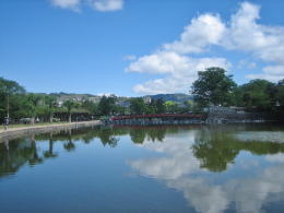
View northward from inner castle-moat
|
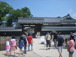
Kuromon, a gate to the main tower |
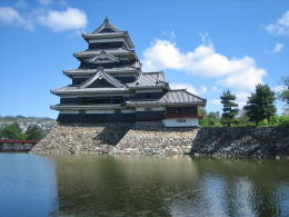
Towers looking like floating on water
|
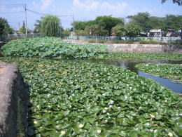
Huge colony of lotuses on moat, summer
|
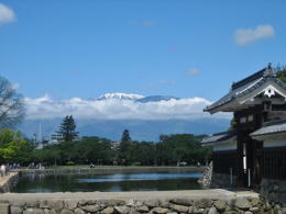
Alps summit covered with snow, a view from front of Kuromon |
|
|
- Map made by commitee fpr cultural assets
- Usuful for town walking!
- defence concept of castle
- Allocation of moats
|
|
|