本文へスキップ
長野県松本市丸の内


■ほかのまちあるきサイト■

松本城公園  

  現在の松本城公園は、天主がある本丸と内堀、そして本丸を東南西の三方から取り囲む二の丸からなっている。
  下の写真は、黒門の手前から西方を眺望して撮影した。城の西には北アルプスの山々が峰を連ねている。その反対側、東方には美ケ原高原を眺めることができる。

Article in English Ninomaru section of the Park

Matsumoto Ccastle Park is consist of two sections, i.e. Honmaru in which the main tower-complex stands, Ninomaru which encircles Honmaru.
In the park we can look at Northern Alps Mountains westwards and Utsukushigahara Highlands eastwards. The photo below shows the summit of Jonendake of Alps.

The picture-map tell us that in the usual (daily) administration the buildings and facilities of Ninomaru were more important than the main towers of Honmaru.
《松本城の縄張り図》 shows us that Ninomaru surrounded Honmaru on three sides, putting the moat between them. And Sannomaru encircled them with Soto-bori, i.e. the outermost moat.
Honmaru was functioning as a symbol of the clan lord's authority in usual and would take a military role in the emmergency, for example in a war.

▲天主の背後で雲の上にそびえる残雪の峰は常念岳

  この絵地図と二の丸公園の説明板から、江戸時代の松本藩の日常的行政の実務においては、本丸よりも二の丸の建物や施設の方が大きな役割を果たしていたことがわかる。
  松本城の縄張り図によると、二の丸は、本丸を東南西の三方から「コの字型」に取り囲んでいた。そして、外堀の外側で本丸と二の丸を四方から取り囲んでいたのが三の丸だった。
  本丸は主に「藩の統治――藩主の権威――の象徴」として機能していて、非常時の軍事的役割や日頃の練兵活動に役立てられていたのかもしれない。

■二の丸めぐり■

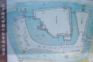
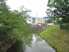
  城郭公園に北西端の入口から入ると、内堀の反対側に蓮池がある。これは、その昔は二の丸の外側の堀に続く水濠だったが、今では四囲を埋め立てられている。

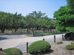
  蓮池の南側は樹林帯で、主に小ぶりな樹高の梅園となっている。公園内の絵地図によると、ここには江戸時代、八千俵蔵と呼ばれる穀物倉庫群があったようだ。

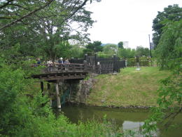
  公園の北端の堀畔は今では道路になっている。堀に沿って東に歩くと、木製の橋が見えてくる。それを渡ると二の丸公園に入る。


右手の土塁は二の丸の北東端。
見張り台が一段高くなっている。

Article in English Walk around Ninomaru

A northwest part of Ninomaru moat is now a lotus pond. Though in those days it was much a larger water-pool of the moat, it has been reclaimed almost parts until now.
On the westside of it is now a field of Ume trees where several warehouses called Hassenbyo-gura were standing in Edo period.

As I mentioned before, on the northside of the moats runs a avenue. Walking along it eastwards, I found a wooden bridge over which I entered Ninomaru garden.

There is a mound-place like a lookout at the east corner of the site. Looking down from it, I found a large lawn field where the Palace of Ninomaru was standing once.
It had remained until the beginning of Meiji era and had used for a central prefecture hall. But in a time thereafter it was burned out.

I recommend to look around from Taiko Turret which is standing on the Taiko-mon. Then you would enjoy a wonderful wide view of the city and mountains.

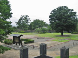
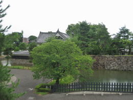
  二の丸公園の東北端には、一段高くなっていて見張り台のような場所がある。
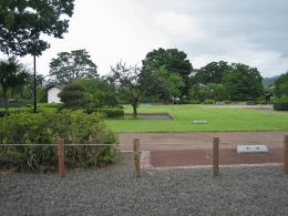
  そこから二の丸を見おろすと、芝生の広場が見えるが、そこには昔、二の丸御殿があったという。
  広壮な二の丸御殿は明治維新後も存続し、廃藩置県後には筑摩県庁として機能していたが、まもなく焼失してしまった。

  二の丸御殿は失われてしまったが、土台は残っている。広々とした芝生の広場を歩き回りながら、御殿の柱の礎石を辿ってみるのも面白い。
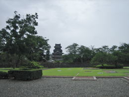
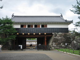

太鼓楼から外堀越しに本丸を見る

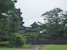
  さて、太鼓門の上に太鼓楼があるが、階段を上って周囲を眺め回してみることをおススメする。もちろん、城から市街や周囲の景色を眺めるには、黒門から天主に上るのが一番なのだが。


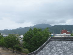
【写真上】太鼓楼の踊り場から北東を眺めてみた。松本盆地を縁取りする山並みの高さは標高1000mくらいだ。その尾根筋の上に顔を出しているのは、戸谷峰(標高1629m)。
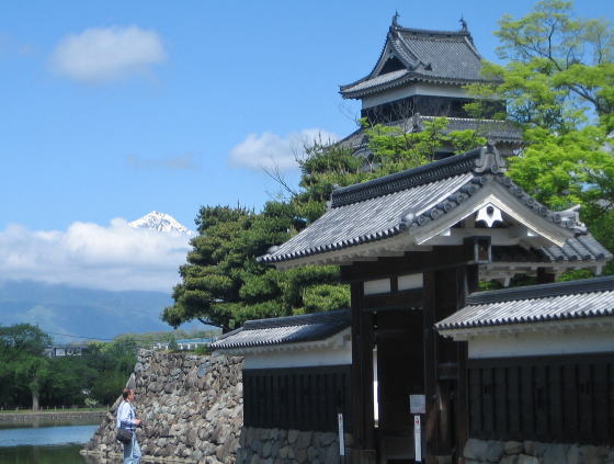

▲周囲を埋め立てられて今では蓮池
▼八千俵蔵の跡は梅林となっている

二の丸公園の出入口となっている木橋

二の丸東南端の土塁から御殿跡を見おろす。芝生の奥には、明治時代のはじめまで二の丸御殿があった。

▲二の丸御殿跡越しに天主を望む
▼本丸の石垣は高く、天主と乾小天主がそびえる

太鼓楼の脇から北方を眺望

二の丸側から太鼓門を見る

松本めぐり歩き

松本城周辺の絵地図

  • お城の近隣の文化財を案内
  • 街あるきに役立つ

松本市 高原の旅

松本城の縄張り絵図

  • 江戸時代の縄張りを図示
  • 堀の配置がよくわかる
のんびり写真館

街歩き写真館

木曾路・奈良井の心に残る風景写真を特集

  • 街並み景観、風物
          フォトギャラリー
  • 木曾路・奈良井散策

  小布施まちあるき

  別所温泉まちあるき

  塩田平をめぐる旅

  木曾路をめぐる旅

  信濃の仏塔めぐり

  前のページに戻る | 次のページに進む |