本文へスキップ
長野県南木曽町吾妻
 
◆ブログ風記事案内
   木曾路奈良井宿
 
街歩きを楽しむ

【写真下】 発電所を過ぎたあたりで街筋を観望する。この辺は「尾又」と呼ばれる。右手(東側)には山腹が迫っているので、家並みはない。
 手前の辻を左に曲がると、蘭川あららぎがわに架かる尾又橋に行く。
    ⇒妻籠宿全体の絵地図を見る

Article in English A view after passing by the power-station.
In Omata zone the town-shape has been conserved very well. A mountainside is pushing out to the eastside of the street.
Turn left, we arrived at Omata bridge over the river Araragi.


■木曾路と妻籠宿■

Article in English Tsumago Town in Kiso Area

Nakasendo which goes from Kyoto to Edo was called also Kiso-kaido.
Among the stage-towns of Nakasendo the towns from Magome to Niekawa were called the Eleven Stage-Towns in Kiso.
Kiso area was administrated by Owari-Tokugawa lord. Its northern border was Sakurazawa.
On the brookside of Sakaigawa in Sakurazawa stands a stone monument, the words of which tell us from here southwards is Kisoji.
As Sakai means the border, the brook drew the country-border between Owari and Shinano.

  京と江戸を結ぶ中山道は、木曾街道とも呼ばれていました。
  このうち木曾十一宿とは、馬籠から贄川までの11宿が位置する部分です。
  木曾谷は、北は尾張徳川領の境の桜沢という場所まで続いていたのだとか。
  桜沢の境川の近くには、「是より南木曾路」という石碑が建立されているといいます。
  境川は、その名のとおり、その昔、尾張と信濃の国境を画していたのです。
⇒木曾路全図(絵地図)を見る

蘭川あららぎがわに沿った街道と街並み■

Article in English Kaido and Town along Araragi River

Kisoji is the road which goes on the valley called Kiso-Dani sorrounded by steep mountains.
Tsumago was the forty-second stage-town from Edo-Nihonbashi among 69 towns along Nakasendo.
As Tsumago is the place where Kiso-Dani valley meets the valley on the south end of Kiso-Mountains, it is key town where Nakasendo meets Ohira-kaido (Ina-kaido).
On the northside of Tsumago, Kisogawa river bumps against the huge mountain-rock and turns west keenly. Thus the river has carved out a deep valley.
Then Nakasendo had to left the river and run southwards along the river Araragi, which is one of branches of Kisogawa. The ravine made by Araragi river is softer than valley of main stream of Kisogawa. The town having grown there had become a key traffic point where main roads met together and thus people and commodities concentrated.

  さて木曾路は、険しい山々に取り巻かれた木曾谷を行く道です。
  妻籠は、中山道69次のうち、江戸日本橋を出てから数えて42番目の宿駅です。
  木曾谷と木曾山脈の南側の峡谷が出会う妻籠は、中山道が伊那街道と出会う要衝でした。

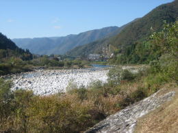
  妻籠の北側で、木曾川は東西に延びる険しい山塊にぶつかって、西に大きく蛇行します。そのため、木曾川は深い谷を刻むことになります。

  それまで木曾川に沿っていた中山道は、本流を離れて支流の蘭川あららぎがわに沿って南下します。
  同じ山のなかでも、少し高低差のゆるい馬籠から妻籠のあいだに街道がつくられたのです。

  というわけで、街集落として、妻籠は交通・物流の要衝として古くから栄えたようです。馬籠峠を挟んで向こう側の馬籠も、美濃の平野部から木曾山中への入り口として、同様にして栄えました。
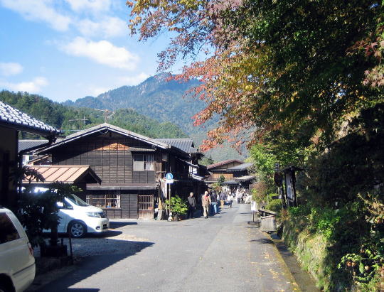
◆尾又地区を歩く◆

Article in English Walk around Omata

In those days, travellers who had come over Magome-pass would walk over Tajima bridge and get into Tsumago town.
As the mountain-hill ( and woods ) are pushing out to the eastside of the Kaido-road, the houses stand only on the wastside.
Under the mountain-foot stands a small shrine house called Misguchi-sama or Oshagoji-sama.
Once here was the crossroads where Nakasendo branced off Ohira-kaido. Then people called such aplace Omata. Omata means a crossroads.
After walking along the street for 200 meters northwards, we find the rows of houses on both side.
There a westbound-road branches off the street. It reaches an old bridge of reinforced concrete called Omata-bashi, which is so narrow that only one car can pass.
Just beside it is a wooden brige for walkers. A pair of biridges are lying over the river Araragi which runs from south to north.
Upstream near the bridges a samall water power station is standing on the eastside of the river. Under the power station is a dam regulating water depth.

  さて、私は南から馬籠峠を越えてきた旅人の気分で歩いてみることにしました。
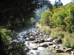
  大妻籠を過ぎて、田島橋の手前から蘭川あららぎがわに沿って妻籠宿に入っていきます。

  まず土産品店があって、ここから家並みが始まります。
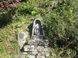
  けれども200メートルほどは、街道の右(東)側には急斜面の山林が迫り家はほとんどありません。ところどころに石仏があります。
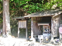
  張り出した山腹の下に「御左口みさぐち様」(「おしゃごじさま」ともいう)の祠があります。
  ここは、その昔、中仙道と伊那街道(大平街道)との分岐点でした。
  地区の名前の「尾又」とは、追分、つまり街道の分岐点を意味します。

  ようやく街並みが始まろうとするところで、西(左)に向かう道が分かれます。
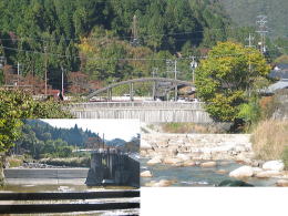
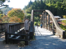
  その道の先に尾又橋が見えます。古い鉄筋コンクリートの橋で、車が1 台ようやく通れるような狭い橋です。
  すぐ左隣に歩行者専用の木造の橋が架けられています。
  橋の間近の上流には水路式の水力発電所があり、川岸に放水口があいています。そして、川の水量調節用の堰堤も置かれています。


木曾川河川敷

木曾川の流れ(大桑村)

         あららぎ川

妻籠宿の西を流れる蘭川あららぎがわ

みさぐちさま

尾又にある「おしゃごじさま」の祠。往時ここは、
木曾街道と大平街道(伊那街道)との分岐点
だったという。説明板によると、土地に宿る
精霊神=「御左口神」を祀るらしい。

斜面の石仏

張り出した斜面に祀られた石仏

堰堤と尾又橋

尾又橋のすぐ上には堰堤がある。

尾又橋

蘭川にかかる尾又橋

 
木曾路を学び体験するために

鳥居峠トレッキング

  • 奈良井から薮原まで鳥居峠を越える道を歩きます。
  • あなたも歩いてみませんか。

信濃川の源流、奈良井川(準備中)

  • 奈良井川は松本平でいくつもの河川と合流して犀川となる。犀川は千曲川と合流し、越後に出て信濃川となる。雄大な流れは日本海に注ぐ。
  • 中部地方の大河川マップ。

奈良井の街並み絵地図

  • 奈良井宿の街筋全体を図解した絵地図です。
  • 街並み探索、街めぐりに役立ちます。

木曾路の絵地図

  • 木曾路のすべての宿駅を表示した絵地図です。
  • 木曾路一帯の名所や観光施設の案内に役立ちます。

中山道の絵地図

  • 京と江戸を結ぶ中山道(木曾街道)の絵地図です。
  • 東海道や日光街道、甲州街道、北国街道との連絡を図解。
のんびり写真館

街歩き写真館

木曾路・奈良井の心に残る風景写真を特集

  • 街並み景観、風物
          フォトギャラリー
  • 木曾路・奈良井散策

奈良井まちあるき

小布施まちあるき

別所温泉まちあるき

塩田平をめぐる旅

前の記事に戻る | 次の記事に進む |