本文へスキップ
長野県木曽郡南木曽町吾妻


街歩きを楽しむ

【写真下】光徳寺下の街並み    ⇒妻籠の街筋の絵地図を見る
寺下の街並みは、妻籠のなかでも江戸時代末の街の姿を最も色濃くとどめている。この数十メートル先には「桝形」がある。

Article in English The picture beneath : A row of town-houses in Terashita zone

The houses under Kotokuji keep the feature of town in the last phase of Edo period.
Over there Masugata is remained. It was a military apparatus.

妻籠の街並み


■桝形が意味すること■

Article in English Significance of Masugata

Sankin-kotai was the travel of lords for greeting Shogun in Edo to demonstrate his loyalty. It was the army-marching in a way.
The official inn of the stage-town was prepared for the lords and Shogunate-officers. It was called Honjin or Jinya, i.e. a headquarter camp-formation for warefare, owing to the custom of the war-age.
The stage-town was formed on the military principle. Each stage-town had to keep some staples for military horses and some warehouse for arms (swords, lances, and guns).
Masugata was a square-structure covered with stone-walls or banks.
It was a defence-apparatus which hindered the enemy soldiers from rushing straight. To pass by Masugata and get into the stage-town, soldiers must turn in right angle twice.

  江戸幕府が定めた街道と宿駅の制度は、運輸交通体系ですが、それはまた徳川王権の権力を担保する軍事施設でもありました。
  宿駅で幕府の役人や参覲の藩主など公用の旅客を停める宿泊施設が、戦国の遺制にならって「本陣」とか「陣屋」と呼ばれたことでもわかります。ことに藩主の参覲の旅は、江戸に向けた行軍を意味しました。
  なかでも、街道と宿駅が軍事施設だと一番強く感じるのは、「桝形」です。
  宿駅の街筋の両端に、石垣で囲んだ土塁を築いて、2回直角に迂回させて、街道を直進することを防いだのです。
桝形の解説を見る

■尾又から寺下まで歩く■

Article in English Townscape of Omata and Terashita

Let's walk along Kaido-street again. We watch a row of old town-houses only on the westside of the street for a while. The houses of the old architecture, charactaristic for Kiso area, are very beautiful.
In Omata there is a famous old shop which has made and selled Getas since Edo-period.
In Terashita houses are standiong on both side of the street except for a place just beneath Kotokuji temple. There a steep mountain-ridge pushing out.
Just beside the stone-stairs to the temple standing a pair of stone Buddhas of Kanzan-Jittoku who were monks in ancient China.

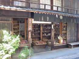
  さて、街筋に戻ると、「ねずこ下駄」の看板を掲げる店。「ネズコ」は、ヒノキとともに木曾の山林で豊富に採れる樹種で、上質な木工品ができます。

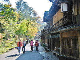
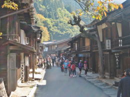
  尾又では、街道の東側に山が迫っていて、家並みは街道の西側だけです。ここから「寺下」と呼ばれる区画まで、西側に美しい家並みが続きます。
  寺下では街並みは道の両側にあります。峠を下りてきた道のせいか、道は緩やかに下っています。
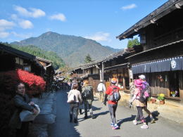
  家並みがしばらく続いたところで、光徳寺の下まで来ると、ふたたび急な斜面がせり出して、街道の東側の街並みが途切れます。そして、道は右に緩やかに曲がっていきます。
  寺の真下、石段の横には「寒山拾得の石仏があります。双体(2つ)の仏が彫られていて、ほかに類例がないといいます。

◆旧街道の面影と桝形◆

Article in English Houses Have Kept Features of the Old Days

Let's walk along Kaido-street again. Right under the temple, the road diverges into two. One is the new road. Another is the old Kaido-road which is going slightly down. Along it an old inn and some tourist-shop whose houses have been keeping the old shape.
The old road turns twice because Masugata hinders going straight.
Such a form of Kaido-road is regulated by Shogunate governmant from the military view point.
Kotokuji is standing on the ridge-hill covered with stone-wall. I think that the temple and Masugata are facing each other across the street may have some military meaning.

After Kaido-road goes around the mountainside, it goes up northwards. Tsumago town is lying on the long hill-side slope in the ravine. Then houses are standing on the terraces.
Such a town-shape has a cubic effect for our eyes.

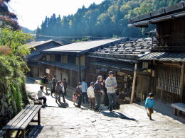
  ここで道は2つに分かれます。左に行く狭い道は昔の木曾街道で、少し下り加減です。民宿旅館や土産品店などの古い建物が並んでいます。
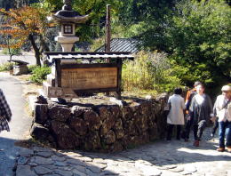
  旧街道はここでほぼ直角に2回曲がります。桝形という石垣土塁によって、街道が二度直角に曲がらないと進めないような形になっているのです【写真下:桝形跡】。⇒参考記事

  これは、街道と宿駅が、元来は幕府の統治ならびに防衛のための軍事施設だったからです。

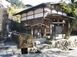
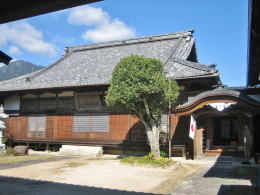
  街道の右側には急な山腹を上る石段があって、これは光徳寺に登る参道です。
  光徳寺は、石垣でかためられた尾根山腹に位置していて、まるで城のようです。
  桝形と石垣の寺が街道を挟む形で対になっていることには、政治上・軍事上 の意味があったのかもしれません。
  街道は寺がある尾根を回り込むように湾曲していて、そこから道はかなりの登りになります。
  ここからの妻籠の街並みには、大きな高低差があります。寺下からずっと北に向かって登りつめていくことになります。
  この高低差によって、宿場の入り口に立つと、独特の奥行きというか、立体感を感じます。
⇒尾又〜寺下の街並みを詳しく見る


下駄屋さん

特産品「ねずこ下駄」の店舗。店主が高齢化したため、残念ながら営業は停止した。

尾又の街並み

尾又地区では道の東側に山腹が
迫っていて、家並みは片側だけ

寺下の街並み

寺下界隈

寺下あたりに来ると、道の両側に町屋が並ぶ

寒山拾得の石仏

光徳寺の真下でふたたび山がせり出す。
そこに「寒山拾得の石仏」が祀られている。

最も古い姿をとどめる家並み

光徳寺の本堂

石段を上ると光徳寺(本堂)
 
木曾路をもっと知ろう

中山道の絵地図

  • 江戸時代に幕府が定めた主な街道と中山道の絵地図です。

中山道宿駅一覧絵図

  • 中山道のすべての宿駅を一覧する略絵図です。

木曽路の観光案内絵地図

  • 木曾路のすべての宿駅を一覧する略絵図です。
  • 近隣の名所や観光施設がわかります。

近隣の主要河川の絵地図

  • 信濃川と木曾川の水系を図に示しました。
  • 中部地方や甲信越、関東の主な河川がわかります。

奈良井の街並み絵地図

  • 奈良井宿の街並み全体を図解した絵地図です。

鳥居峠トレッキング

  • 昔の中山道木曾路の面影を訪ねる峠道のトレッキング
  • 奈良井から藪原までを歩いてみませんか
  • トレッキングコースの図解があります
のんびり写真館

街歩き写真館

木曾路・奈良井の心に残る風景写真を特集

  • 街並み景観、風物
          フォトギャラリー
  • 木曾路・奈良井散策
 

奈良井まちあるき

小布施まちあるき

別所温泉まちあるき

塩田平をめぐる旅

   
前の記事に戻る | 次の記事に進む |