|
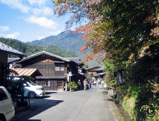
【Picture beneath】 A townscape of the place called Omata over a power station. Omata means a crossroad point at the end of the town. On th right side of the road, as a rige is creeping behind, there no house stands.
Turning left at the crossroad in front, we would go to Omata-bashi bridge over Araragigawa river.; ⇒Picture Map of Tsumago
■Kisoji and Tsumago■
Nakasendo, coneccting Kyoto and Edo, was called Kisokaido. Kiso area had eleven stage towns in the road.
The north border Kisoji was the place Sakurazawa.
A stone monument, standing on the riverside of Sakaigawa, tells us that south of there is Kisoji. Untill Edo period, it had been the border of two countries.
Sakaigawa, i.e. a river of the border, literally showed the border between Owari and Shinano.
⇒Simple Map of Kiso Area
■Town Shape along Araragigawa■ |
|
Kisoji is the way running through the long valley surrounded by steep mountains.
Tsumago was the 42th stage -town from Nihonbashi in Edo among 69 stage-towns in Nakasendo.
Tsumago is a key point where Kiso valley meet the one on the south side of Kiso Mountains (Centrel Alps), where Nakasendo met Inakaido. The crossroad was named Omata.
For Kisogawa river has been blocked by huge mountain -clusters, it has turned south and carved a deep valley. Too steep landforms.
Then Nakasendo separated itself from the valley and ran along Araragigawa, a branch of Kisogawa.
Kaido was built on the easier ravine between Tsumago and Magome.
Thus Tsumago had been prosperous as a terminal town of traffic since ancient days. Likewise Magome had grown at another end of the pass as a entrance to Kiso area.
◆Walk around Omata◆
In old days travellers who had come over Magome-Toge, went through Oatsumago and arrived at Omata, the south end of Tsumago.
Now we find there a shop for tourists. It is a end of the serial town-houses on the west side of the Kaido.
For 200 meters long there no houses on the east side of the way, as woods on ridgeside are reaching there. On road-side stone Buddha statues are scattering.
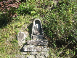
A small shrine house called Misaguchi-sama or Oshagoji-sama are lying under the ridge-side protruding to the road.
Such shrine used to be standing at the crossroad in Shinano. Once there was a meet point of Nakasendo and Inakaido (Oohirakaido). But now there are covered with the wild grass.
After walking for a while, we find a way branching off westward. The way get to an old bridge, made of concret, over Araragigawa.
It's so narrow that only one car can run through. Then a wooden bridge fow walkers is added beside it.
Near the bridge upstream, there is a water power-station with waterways. We would find a drainage canal on the riverside where a dam controls flow of water.
|
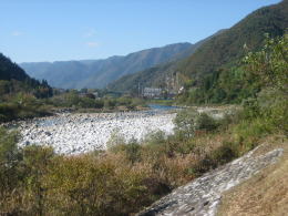
Kisogawa flows
|
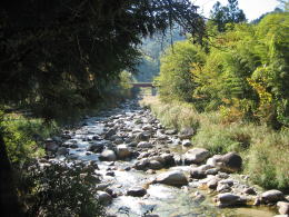
Araragigawa flows on westside of Tsumago
|
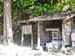
The small shrine house of Oshagoji-sama in Omata was
standing at the crossroad of Nakasendo and Oohirakaido.
The information bord tells us it is the spirit of land. |
|
A stone Buddha statue on roadside |
|
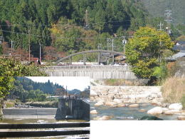
A dam of power station near the bridge |
|
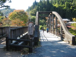
Omatabashi, a bridge over Araragigawa |
|
|
- Describing Nakasendo as a whole from Edo to Kyo
- Showing the connection with other main Kaido roads
- Showing all the Stage-Towns in Kiso area
|
- Describing the town shape as w whole
- A guide for town-watching
- Describing the town shape as w whole
- A guide for town-watching
- Describing the town shape as w whole
- A guide for town-watching
- Explaining design of the town-house
- Investigating the life-style of people from the house-design
|