本文へスキップ
Ootsumago, Kisomachi town, Nagano Pref.
 
  Walk into the pass of Magome-Toge from Tsumago town, we find a small town Ootsumago on the steep of the deep ravine-side. The town looks like that on the sky. Walking around the town, let's imagine the old shape of Kisoji.
  Photo : A narrow path to Maruya

 
The Noth End of Mgome-Toge Pass

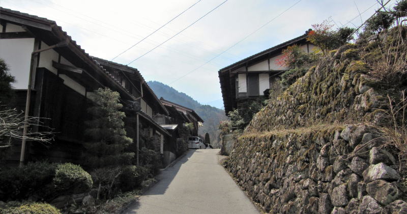
  When visiting the stage-town Tsumago, you had better go to Ootsumago, a small town on the steep slope of the deep ravine-side. The town is at the entrance to Magome-Toge pass, 1.5 kilometers southward from Tsumago. You must feel comfortable, finding a Japanese historic home town.
  Starting from Omata, the south end of Tsumago town and walking over Araragi bridge, you will get into the Prefectural road 7. Then come into a narrow path, you would already get to be in Ootsumago town. In Japanese Tsumago means a deep end of the ravine and Ootsumago means the deepest end of it.
  It is a very tiny town, where the old houses from Edo period have been conserved. ⇒Walking Map along Magome-Toge


▲The houses along the path near from Pref. road

  I would like to recommend to walk around four zones mentioned below.
  1) the zone near Kongoya and Naraya, where introduced this page.
  2) the neighborhood around Maruya inn.
  3) the zone near the old house of the Fujiwaras, 600 meters on upward-way from Maruya.
  4) Shinmei zone, 100 meters northeastward from Kongoya.
  I visited there on mid March, when the winter air was lasting.


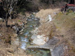
▲The houses on ta steep slope of the ravine, from the brook-side of Otarugawa

■Town sticking on the ravine-side■


Otarugawa running down on the ravine-bottom

  Walk around the first zone mentioned above.
  I began to walk from the big sign-bord of Ootsumago into the path in the town. The brook flowing down under the village houses is Otarugawa.
  After walking along the path 100 meters downward, I found a bridge over Otarugawa. It is Myojin-bashi. Climbing up along the path, I observed carefully the rows of old houses sticking on the ravine-side slope. Here is a entrance to Magome -Toge pass.


▲Walking along a path from the pref. road 7

  That is the very scene that is nearest the townscape in Edo period. I call it the old scene of Kisoji-Nakasendo.
  The house-sites, like terraced fields, are sticking onto the steep slopes. They are sustained with stone-walls. The old houses are standing together swarmly. Walking up along the slope-path is hard exercise.
  However, I could not but walk on, moved by the townscape beautiful and nostalgic.


▲A stone-monument and the water-well under the cave

  Ootsmago town is so popular for European and American people that many people are coming here to experience the scene of Japanese home town.


Otarugawa flowing down to meet Araragigawa


The houses on the stone-walled terraces

There are no ways but the slope paths

Climbing up the old Nakasendo

An old house with no sign of people's life

The inclination ow path is such !

Old houses on the stone-walled terraces

Look up Kongoya, a Soba restaurant

Kongoya is standing along the pref.road
 
Information

妻籠宿街歩き絵地図

  • 妻籠宿全体の絵地図です。
  • 街歩きに役立ちます。

馬籠峠を歩く

  • 馬籠宿から妻籠宿まで馬籠峠を越える道を歩きます。
  • あなたも歩いてみませんか。

和田宿街歩き絵地図

  • 和田宿の中心部を詳しく案内。
  • 宿駅の前後の街歩きも案内。

和田宿の歴史絵地図

  • 中世城下町の時代からの変遷を説明。
  • 宿駅の発展の痕跡を訪ねる。

和田峠トレッキング案内絵地図

  • 和田峠めぐりするための絵地図。
  • 峠の史跡や名所をガイド。

和田宿近隣散策

  • 和田駅ステーションから
  • 和田宿温泉ふれあいの湯まで

江戸時代の追川付近の街道

  • 路面地形の断面図で解説。
  • こんなにも街道交通は大変だった。

中山道の歴史

  • 中山道に即して街道制度の歴史を説明。
  • 幕藩体制と街道・宿駅との関係を考える。

中山道の町家造りの説明

  • 中山道宿場の町家造りの仕組みの解説です。
  • 街並み探索がもっと楽しくなります。

木曾路の絵地図

  • 木曾路のすべての宿駅を表示した絵地図です。
  • 木曾路一帯の名所や観光施設の案内に役立ちます。

中山道の絵地図

  • 京と江戸を結ぶ中山道(木曾街道)の絵地図です。
  • 東海道や日光街道、甲州街道、北国街道との連絡を図解。
のんびり写真館

街歩き写真館

木曾路・奈良井の心に残る風景写真を特集

  • 街並み景観、風物
          フォトギャラリー
  • 木曾路・奈良井散策

奈良井まちあるき

小布施まちあるき

別所温泉まちあるき

塩田平をめぐる旅

◆ブログ風の記事案内を見る

|  next page  |