本文へスキップ
Tsumago, Nagisomachi, Nagano Pref.


Shape of Tsumago Town

【Picture beneath】 A townscape just down Kotokuji temple
;⇒Picture-Map for Town-Walking of Tsumago
Terashita means the place just down(under) the temple. The street and houses has kept best the shape in the last phase of Edo period. Over there is a Masugata as a military apparatus.

妻籠の街並み

■What Masugata Means■

  Sankin-kotai was the travel of clan-lords for greeting Shogun in Edo to demonstrate his loyalty. It was the army-marching with right armourment in a way.
  The official inn of the stage-town was set up to service for the clan-lords and the officers of Shogunate government travelling along Kaido. It was called Honjin or Jinya, i.e. a headquarter camp-formation for warefare, owing to the custom of the war-age.
  The stage-town was mainly formed on the military principle, on the other hand it was a transport institution designated by Shogunate government. Each stage-town had to keep some staples for military horses and some warehouse for arms (swords, lances, and guns), which samurais took with them in marching trip.
  Masugata was a square gate-way structure covered with stone-walls or banks.
  It was a defence-apparatus which hindered enamy soldiers from rushing straight into the town. To pass by Masugata and get into it, the soldiers must turn in right angle at liest twice.
⇒Explanation of Masugata
  On the other hand, the clan-lords staying at Honjin had to get on their guard by disposing their soldiers at some warning points, including Masugatas in the town, because Sankin-kotai was one of the important military services for Shogun. If they failed, the clan had to be abolished.

Simple Map of Kiso Area

■From Omata to Terashita

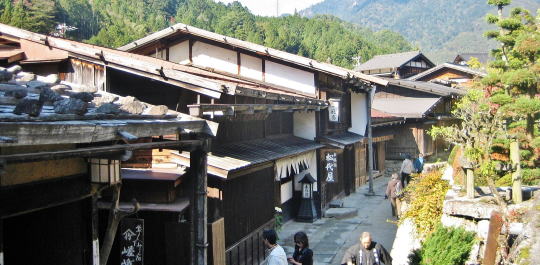
  We would find s famous shop selling Nezuko Getas at the end of the town bloc. Nezuko is a kind of acerose trees including Hinoki. They can collect a huge volume from mountains in Kiso and make high-quality wooden works of it.

  In Omata area the mountain-side hill is rushing on the east side of the street, the houses are standing only on the westside. But we would see the old and beautiful townscape from there to Terashita.
  Untill Terashita the way goes slightly down, as it comes down from the pass. Here the houses are standing both side of the street. But the row of the houses is disapear just under Kotokuji temple, at which the hill are protruding to the street. And the way turns east slightly.
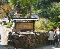
  Just beside the stone stair-way toward the temple, the stone Buddha statue which deified from the saints in the ancient China is standing under a cover-house. On one stone two saints were carved. Such a perculiar statue has never been found in other places.

◆Scene reminding old days◆

  Here for some length two ways goes in paralell. The one goes down is the old Kaido and another one upward is the new, built for car traffic. A few guesthouses and shops selling folkcraft-works for tourists are standing along the old one.
  The old one turns twice in right angle, hindering by the stone -walled mount and the foundation -work of houses. It is Masugata.

  It is because Kaido and the stage-town was some kind of the military institution.

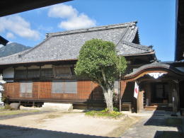
  Moreover the geographic location of Kotokuji temple, looking like a castle, had a military significance. It has been on the stone-walled hill, from which theu could watch ovet the town.
  The local agency of the Yamamuras' administraion could allocate their soldiers in the precincts of the temple on the hill. The structure that the temple and Masugata were facing each other across the road has military role.
  Here the way come at the bottom of the ravine, from here the way goes upward.

          下駄屋さん
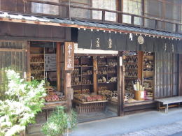
A shop selling Nezuko Getas

尾又の街並み 
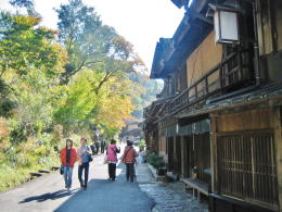
In Omata the mountain-side is creeping to the street

寺下の街並み
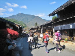
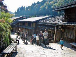
Many tourists walking on the street

寺下界隈
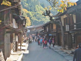
Houses are standing on both side of the street in Terashita zone.
Here the hill retreat from the street.

寒山拾得の石仏
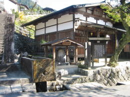
Just under the Kotokuji temle the hill protruding again. On the hill-foot the stone Buddha statue is deified.


The most old houses stnading side by side

Masugata

光徳寺の本堂
石段を上ると光徳寺(本堂)
previous page | next page |
 
Informations

A Picture-Map of Nakasendo

  • Describing Nakasendo as a whole from Edo to Kyo
  • Showing the connection with other main Kaido roads

A Picture-Map of Kisoji

  • Showing all the Stage-Towns in Kiso area

A Picure-Map of Narai town

  • Describing the town shape as w whole
  • A guide for town-watching

A Picture-Map of Tsumago

  • Describing the town shape as w whole
  • A guide for town-watching

A Picture-Map of Magome

  • Describing the town shape as w whole
  • A guide for town-watching

Architecture of Machiya

  • Explaining design of the town-house
  • Investigating the life-style of people from the house-design