|
Nakasendo, the way from Kyo to Edo through several provinces, i.e. Omi, Mino, Shinao, Kozuke, Musashi, was one of main Kaido-roads. It had been called Tozando in the Ancient days. The Road connected with Hokkoku-kaido and Koshu-kaido in Shinao country.
Nakasendo had 67 Stage-Towns as its own ones in the Edo Period. And it shared two common Stage-Towns, Nihonbashi and Kusatsu as the teminal, with other Kaido-roads, for example Tokaido.
Nanaksendo was also called Kiso-kaido or Kisoji in a wide sense, as it ran through Kiso area.
Nowadays we call it National Road No. 19 and its side roads Nakasendo or Kiso-kaido.
In Kiso area Nakasendo is running through the bottom-line of the deep ravine. The road, processing towards south after leaving Shiojiri, is surrounded by high mountains up to Magome.
The chaned peaks of Mt. Ontake-san raise in the west, and the mountains of the Central Alps, whose summit is Mt. Kiso-komagatake, raise in the east of the road. The altitude of Mt. Ontake-san is 3,067 meters and Mt. Kiso-komagatake is taller than 2,950 meters.
⇒Reference note about Naming of Kaido

▲Kisoji is surrounded by huge mountains : in the place near Niekawa
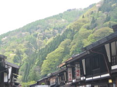
The picture above : Torii-ridge
is drawing behind Narai-town.
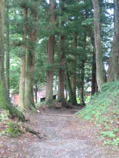
The picture right : Such a scene recall us
the feature of the road in thold days.
|
 |
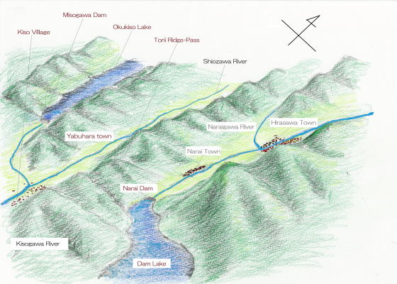
In the whole Nakasendo the zone from Niekawa to Magome is Kisoji in a narrow sense. There have been 11 Stage-Towns, i.e. Niekawa, Narai, Yabuhara, Miyanokoshi, Fukushima, Agematsu, Suhara, Nojiri, Midono, Tsumago, Magome.
For the provincial administrative agency located in Ueda in the Nara Period, we may presume, some kind of fomula of Kaido-road had already been formed in 8th century.
Among those Stage-Towns Narai was well known over almost Japan in the Kamakura Period (12th century).
◆Ridge-Line Raising◆
The road running in the ravine is cut off by the steep ridge line. The serial peaks and ridges which continue far from Mt. Kiso-komagatake are straddling in front of the way.
The travellers had to walk carefully over Torii rige-peak, which is creeping near the wast end of Narai town.
As there was only one narrow path through the steep mountain, in the old days the ridge-pass was famous
as the most difficult place in the Nakasendo.
The skyline raising steeply from north to south are the great dividing peaks which dvide two water-systems, i.e. Naraigawa as a branch of Shinanogawa river, flowing into the Japan Sea, and Kisogawa river, flowing into the Pacific Ocean.
Therefore the road from Shiojiri to Narai is a journey raising up and from Yabuhara to Tsumago is a journey going down.
|
|
- A picture-map of whole Nakasendo from Edo to Kyo.
- Shinano country and other main roads connected with Nakasendo.
- A simple map of Kisoji's geography
- Ways, rivers and stage towns
- A picture-map of the rows of the town-houses
- A guidance for sight-seeing of townscapes
- Explain the design of the town-house in Narai
- From the design of houses, learn the lif-style of the people
|
|
|