本文へスキップ
Narai, Shiojiri city,
Nagano prefecture
 
Section Contents
NakasendoKisoji
History of Kisoji
The Stage-Towns
Toiya-Office…
As Military Institute
 
 
History and Geography

  In a narrow sense Kisoji means the section from Jikkoku Ridge-Pass to Sakaigawa of Nakasendo.
  We can trace the history of Kisoji back to the Ancient age (8c.-9c.). Nakasendo was called Tozando then. Nakasendo means the midland way surrounded a lot of huge mountains, and Tozando means the mountain-road towards the east.
  Main villages which would be designated as the stge towns had been come out in 15th century. In 17th century when the Tokugawa Shogunate government instituted Nakasendo as Kaido-system, Kisoji became the key section. Then Nakasendo as awhole was called Kisoji or Kisokaido in a wide sense.

▼Main Kaido Roads in the Edo Period

Nakasendo and Kisoji

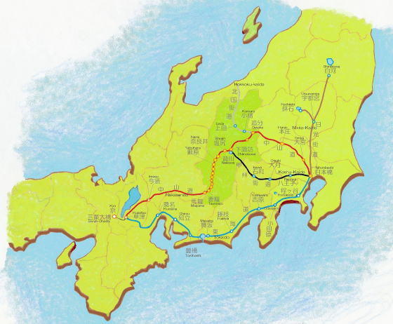
  Nakasendo was the inland road from Kyo to Edo through Omi (Shiga pref.), Mino (Gifu pref.), Shinano (Nagano pref.), Kozuke (Gumma pref.), Musashi (Saitamapref.).  In Shinano country which consisted middle zone of the road, it connected with Hokkoku-kaido, the ways from the coast-areas of the Japan Sea, as well as connected Koshu-kaido to reach Edo.
  Then Nakasendo had kept an important position in the military-economic administration by the Shogunate government.
  In 1602, the Shogunate monarchy instituted Nakasendo as main road of the Kaido-system which had the strategic-logistic importance. Thereby the Tokugawa dynasty build up the Stage-Town system to manage the key towns along the road under the direct control.

  Nakasendo had 69 Stage-Towns including two terminal stages, Nihonbashi and Kusatsu. At both stage the road connected with Tokaido which ran from Edo to Kyo along coasts of the Pacific Ocean.
⇒Reference note about countries and provinces in Old Japan

◆Mountain-road in Shinano

  Coming over Usui ridge pass Nakasendo got into Shinano country. Main stage towns people would follow thereafter were Oiwake, Odai, Mochizuki, Wada, Shimosuwa, Shiojiri. And the first Stage-Town of Kisoji was Niekawa.

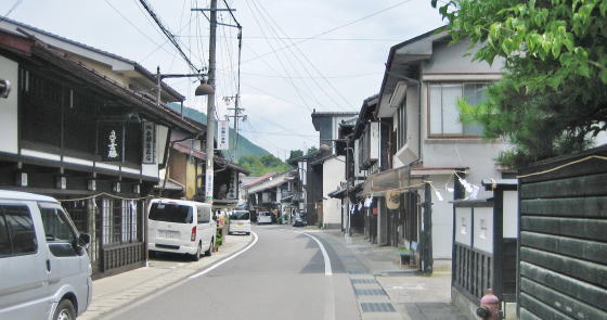
  Kisoji is the way running along the ravine-line surrounded by steep mountains. After leaving Shiojiri, the road is tracing back Naraigawa river on the bottom of the canyon.
  Kisoji had 11 Stage-Towns, i.e. Niekawa, Narai, Yabuhara, Miyanokoshi,fukushima, Agematsu, Suhara, Nojiri, Midono, Tsumago, Magome.⇒Picture-map

 
馬籠峠の道
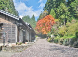
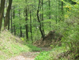
Magome ridge pass in late Autumn:
The old road of Nakasendo repaired.
The road is an inland way.
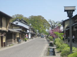
The houses of the traditional architecture in Kiso area are standing by the road now.
After the ridge pass, people walk along the long way through the ravine.

The townscape of Unno-juku of Hokkoku-kaido. This Kaido has some towns keeping the traditional shape.
At Oiwake town the road diverge from Nakasendo. Oiwake means a diverging point.

A beautiful landscape in Saku Basin. Nakasendo goes through Saku basin towards Wada ridge pass.

The features of pass through the mountain-woods are such.
In the old days this path is only way passing over the ridge.

平沢郷の街道
  ▲Hirasawa town of Kisoji today
  Hirasawa is the town allocated between Niekawa and Narai. Its woodwork and Lacquer-Japan industry has been prosperous. The craftmen in this town have been keeping the wonderful technique and skills.


previous page | next page |

About Kisoji

A Chart of Nakasendo

  • A picture-map of whole Nakasendo from Edo to Kyo.
  • Shinano country and other main roads connected with Nakasendo.

A Picture-Map of Kisoji

  • A simple map of Kisoji's geography
  • Ways, rivers and stage towns

A Picture-Map of Narai Town

  • A picture-map of the rows of the town-houses
  • A guidance for sight-seeing of townscapes

Town-House Architecture

  • Explain the design of the town-house in Narai
  • From the design of houses, learn the lif-style of the people