本文へスキップ
Narai, Shiojiri city,
Nagano prefecture
 
Section Contents
Hisoty of Narai
Prosperity of Narai
Commerce and Local Industry
Kaido-road and Growth of the Towns
Further Stories
 
Introduction  

  In 17th century the Tokugawa-Shogunate government instituted the Kaido-system. Kaido was a kind of the logistic highway-system dominatede by the Tokugawa government. Nakasendo was one of main roads consisting the Kaido.
  Each road had the official stage-towns called Shuku oa Juku which was designated by the Shogunate government, and the starting point of every road was Nihonbashi in Edo city. Nakasendo had 67 stage-towns.
  Narai-juku was the 34th town from Itabashi-juku which was the first town after starting from Nihonbashi.
  Narai was the most prosperous town in Kiso area. The town has an old history and its name had already been famous over Japan since the Kamakura-period (12th century).


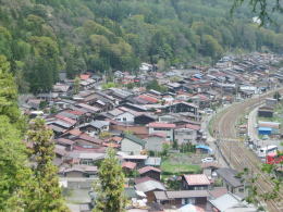
▲Town shape of Narai today

  In the Edo-period, the rows of Narai's town-houses facing the Kaido-road was continued over 1 kilometers. It was excessively huge as a town surrounded by mountains.
  The shape of the town-village as a whole has been untill now basically conserved. There is no other town that has kept the historical landscape in such a large scale in Japan.

◆History of Narai◆

  In the middle age Narai and its peripheries had been administrated by the Narais, the lord family prevailing over the area.
  Since the Muromachi Period until the Age of Wars (14c.-16c.) the zone of the governance-unit had been enlarging. And Kiso area was incorporated into the county dominated by the Yamamuras.

  Narai town was incorporated into the greater polity. While the ecomnomic-commercial connections among areas was getting tighter, the political-military confrontasion among lords was getting more intensive. Smaller units couldn't suvive alone.

  After the alliance of Tokugawas- party lords was getting the predominance and beginning to build up the Shogunate regime, Kiso area was administrated directly by the government in 17th century. And the Yamamuras was designated for a magistrate of the area.
  Then Narai, the biggest town in Kiso area, was allocated as one of the Stage-Towns of Nakasendo. In time Kiso area became incorporated into Owari Tokugawa's fief.

  Long ago people traveled, walking along the narrow paths in the mountain-forests. The ways were dangerous espacially on the ridge-pass. Thus, when travellers got out the forest, they found the Narai town and perhaps felt relief.

 
街並み俯瞰
A view from the rige-pass
杉並木の小径
A Shape of roads in Kiso area in old days :
A narrow path in the woods

The ruin of the Narais' fortress

About Kisoji

A Chart of Nakasendo

  • A picture-map of whole Nakasendo from Edo to Kyo.
  • Shinano country and other main roads connected with Nakasendo.

A Picture-Map of Kisoji

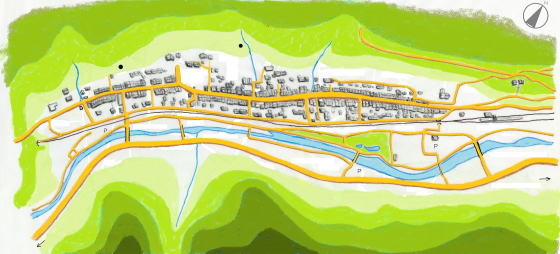
  • A simple map of Kisoji's geography
  • Ways, rivers and stage towns

A Picture-Map of Narai Town

  • A picture-map of the rows of the town-houses
  • A guidance for sight-seeing of townscapes

Architecture of Town-House

  • Explanation about the design of the town-house in Narai
  • From the design of houses, learn the lif-style of the people
のんびり写真館

街歩き写真館

木曾路・奈良井の心に残る風景写真を特集

  • 街並み景観、風物
          フォトギャラリー
  • 木曾路・奈良井散策

  小布施まちあるき

  別所温泉まちあるき

  塩田平をめぐる旅

  木曾路をめぐる旅

  信濃の仏塔めぐり

  previous page | next page |