◆Architecture of French Stlle Stair-Stream◆
Technology of Reconstructing Steep Ravine of Headstream
I would like to explain the architecture of French style Stair-Stream, reffering to the information bords on the side of headstream of Ushibusegawa. The pictures beneath are all from it.
Picture A shows the situation just after construction was accomplished. They had covered all over the ravine-sides and the hollows, which would be water ways, with stone-pavement.
The water-strems made by rainfall would dig the slope earth to carry and pile it on other places, which caused the landslide on the steep ravine-side slope. Then by stone-pavement over it, they hoped to avoid the land-transformation by digging and carrying earth by water.
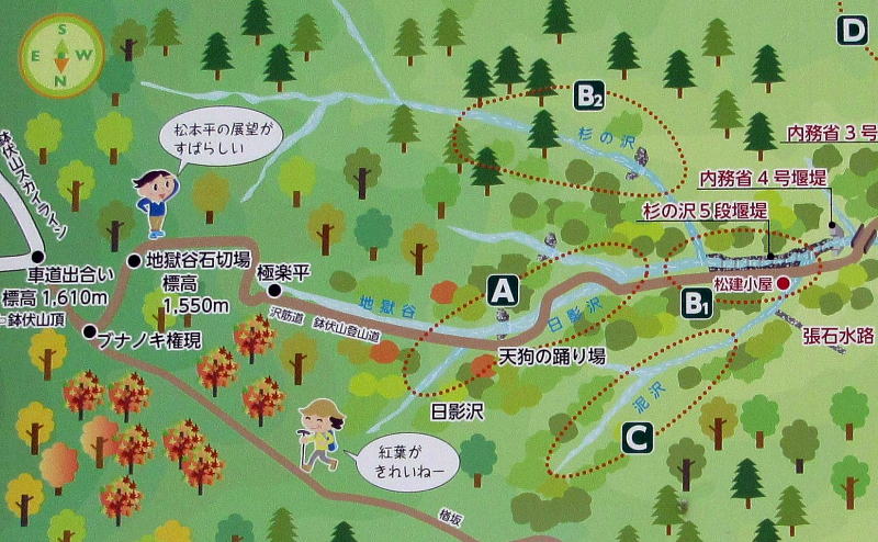
⇒See the place by Google Map
■Technique of Stone-Covering■
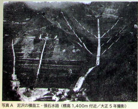
▲Picture A
Going down on the slope a bit, the water get together to form a small stream. They let the water get together into the artificial hollow, to induct it the stream paved with stones.
Thus the waterways as a whole form a tree-shape. As if from small branches to larger one, furthermore to a stem, the waterways would be inducted into the larger streams.
The technique was used for the highest place of the headstream, from the altitude 1600 meters to 1400, all overt the slopes. Therefore some branches of stream (brooks) would be formed at the altitude 1400m.
By the way, as they didn't used concrete- cement, there are so many gaps between each stone, that some deal of water intrude into the earth. Not all the volume of water flow and get together into the paved stream.
Some volume of water intrude into the earth to be pooled as groundwater and to go down in a long time.
Thus by reconstructing all the steep ravine-sides, they would avoid invasion- and accumulation-effects of water which would transform the slope.
■Replanting technique■
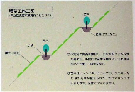
They piled earth on the paved slopes to make soil and transplant grasses on it to prevent the earth from sliding down. The roots of grasses keep the soil.
If the vertical gap of slope is so large that the rainfall-water get together to transport the greater deal of earth downward. There are some threat of soil-outflowing. To avoid it, they built some terraces on the slope to shorten the height-gaps.
And they piled the earth on each terace to make soil and transplanted the saplings to make the forest. In time tree-roots would grip the soil and keep water around them to form the stable ground. They reconstructed the ecology system around te ravine.
■Present Shape of Slope■
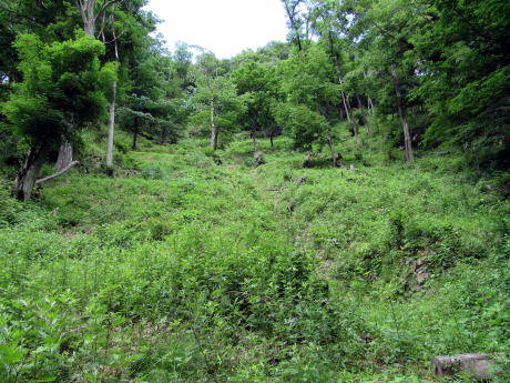
In that way the ravine-side slopes have been covered (susteined) with stone-works which have been covered with soil and plants.
The picture on the right hand shows the shape of there that has passed over 100 years since then.
The woods are covering all around the slopes. Furthermore they have gradually changed the ecology to conserve the landform. Once they transplant the saplings of black locust and pine, which are too fragile to grip the ground, but now maples and konaras (quercus serrata), which would keep soil more strongly. The aspect of the forest are changing now again.
By the way the ravine-sides are so steep that it is very difficult only to climb it. On such a place they carried up gareat deal of stones and paved them, thereafter piled earth and transplanted trees and grasses. How hard it was ! How clever they were ! I cannot but admire them.
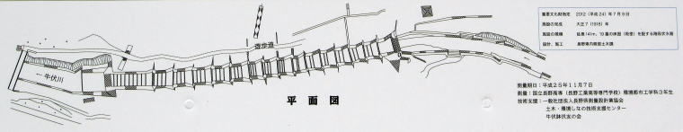
Pictre Map of Headstrem Area
Construction Way of Stair-Stream
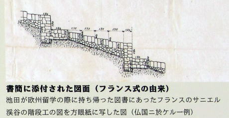
Original design-chart at Sanières ravine, France
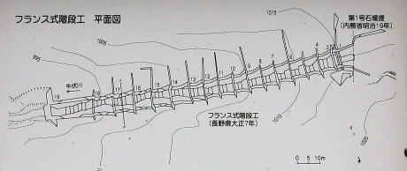
Design-chart of Ushibusegawa headstream
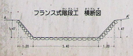
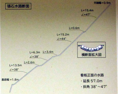
A cross section chart
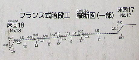
A vertical sectio nchart
The pictures and the explanaitions are quoted from the bords at the scene.
An engineer was sent to France 1911 to study the technology for flood-control on mountains. The stair-stream of Ushibuse- gawa was designed on the base of it and constructed 1917‐18.
Owing to the picture on the right hand, 19 stairs was built in 141m waterway above the first stone-dam.
The structure of the stair-stream at Sanières ravine in France, the most original concept on which Japanese engineers relied, looks heavier and more strict than Japanese one (see the picture abovemost). That of Ushibusegawa looks much easier, maybe owing to national conditions.
The deffernece btween them was partly because that they needed simplification. Moreover Japan's rainfall was so much heavier that by simpler stone-works they had to let more deal of water intrude into the earth in much larger area to diversify it into smaller parts. The looseness was neccesary in Japanese natural conditions.
From a cross section chart, they paved with round stones in order to let water intrude into the earth between them. But acctually they adjusted the stone-shapes to avoid slide or become loose. About the architecture of stone-pavement or stone-wall, they reffered to Japanese traditonal stone-working, for example the stone-walls of castles.
European has tendency to control the nature strictly but Japanese would like to restrict the degree of artificial intervention into the nature according to the natural condition.
⇒◆Walking around the stair-stream◆
A design chart of middle stage of stair-stream
A map from the middle stage of stair-stream to dam-lake(from explanaiton bord)
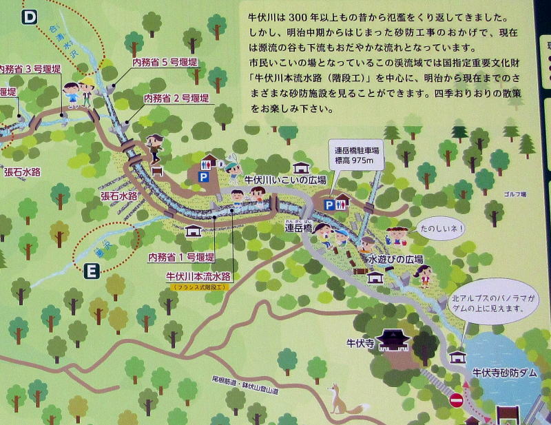
Google Map
| next page || Matsumoto home |